Research leads to food and sport deals
CSIRO has now created more than 150 companies and currently hold interests in around 30. It is also Australia’s largest patent portfolio and issues around 80 licenses each year, many to Australian businesses.
CSIRO Director of Business Development and Commercial Jan Bingley said the deals for BARLEYmax, Zebedee and WASP, further demonstrate how CSIRO was helping build Australian businesses and boost the country’s productivity.
“CSIRO works with about 3000 clients each year, including more than 20 per cent of the Australian Stock Exchange top 200 companies and 1300 Small to Medium Enterprises,” Ms Bingley said.
“CSIRO also has significant partnerships and alliances with domestic and global private sector organisations, including Orica, Cotton Seed Distributors, Boeing and General Electric.
“Our aim is to play an important role in providing Australian industry with access to leading capabilities and technologies that help to improve the productivity or competitiveness of Australia.”
CSIRO has now created more than 150 companies and currently hold interests in around 30. It is also Australia’s largest patent portfolio and issues around 80 licenses each year, many to Australian businesses.
Melbourne based company Catapult Sports has licensed the Wireless Ad-hoc System for Positioning (WASP) tracking and positioning technology and integrated it into their athlete monitoring system to create ClearSky, a new product to enable highly accurate tracking of athlete’s positions and movements in indoor and covered arena sports applications, an application previously unavailable using existing technologies.
“Catapult Sports already have some of the world’s best sports teams using their devices, including almost all English Premier League teams, NRL, AFL, American football and basketball and international hockey, rowing and sailing teams,” Ms Bingley said.
WASP has also been licensed by mining communication company Minetec and incorporated into their Trax+Tags II product for greatly enhancing mining safety in underground, poor visibility environments by keeping miners clear of heavy vehicles and dangerous areas.
WASP can track people and objects to an accuracy of up to a few centimetres, a great improvement on conventional methods such as GPS and WiFi-based tracking, which in underground environments are either inaccurate or don’t work at all.
BARLEYmax is a natural wholegrain with enhanced nutritional benefits. Developed by CSIRO, the ‘supergrain’ contains twice the dietary fibre of regular grains, four times the resistant starch and has a low glycemic index.
Barley Max Enterprises is a new company established by CSIRO and Australian Capital Ventures Limited (ACVL) that specialises in the development and commercialisation of novel grains with known health benefits. Barley Max Enterprises has an exclusive license from CSIRO and ACVL to commercialise the BARLEYmax grain.
“Five Australian companies are now using BARLEYmax grain in their food products, which include breakfast cereals, muesli bars, rice blends and bread,” Ms Bingley said.
BARLEYmax was first made available to Australian consumers as a major ingredient in breakfast cereal products produced by Goodness Superfoods, a Victorian food producer.
Zebedee/SLAM has been licensed by CSIRO to 3D Laser Mapping and has formed a new entity, GeoSLAM, to commercialise the technology. GeoSLAM is 50 per cent owned by CSIRO.
3D Laser Mapping has signed an exclusive agreement to distribute what is thought to be the world’s first, truly mobile, hand held, rapid laser mapping system.
Developed by CSIRO, Zebedee indoor mapper allows for fast data capture, without complex set up or the requirement for lengthy data processing. The Zebedee system can be used by surveying novices in areas without GPS coverage to capture accurate 3D point clouds at speed.
“In February this year, QLD Police announced they had purchased a Zebedee unit and would be using it as part of routine investigations,” Ms Bingley said.
“It has also been used to map the Leaning Tower of Pisa, the Jenolan and Koonalda caves, the Shrine of Remembrance in Melbourne, the Australian War Memorial, the World Forum in The Hague, Fort Lytton, Peel Island and a WW1 tank.”
It has been also used to map crime scenes, factories, forests and some of the world’s largest mines. In all 35 systems have been sold in all parts of the world.
Media resources
Click image for high resolution version.
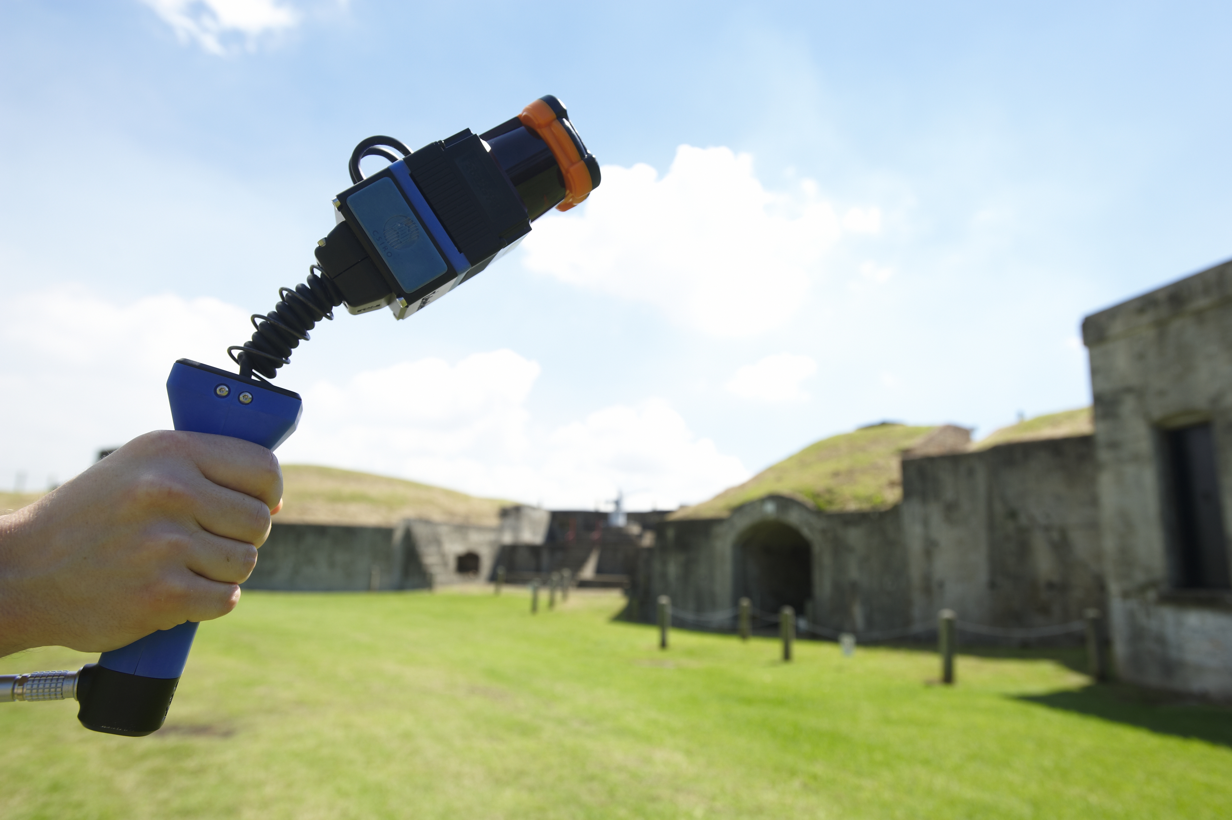
Zebedee scanner in use at Fort Lytton