Remote sensing
Australia is a world leader in the use of remote sensing technologies. This commanding position is largely due to research begun in the CSIRO Division of Mineral Physics in the early 1970s to take advantage of data collected by NASA’s first Landsat multispectral satellite. This pioneering work provided the foundations on which Australian remote sensing is based and also established remote sensing and image processing as an integral part of the Australian mineral exploration industry. The nation’s vast land area and low population, a competitive and technology savvy resources sector and a long history of using aerial photographs for land use mapping all prepared the country ideally to adopt the new global views.
In 1995, CSIRO’s contribution in the field of remote sensing was recognised by the award of the Australia Prize to Dr Ken McCracken, Dr Andrew Green and Dr Jonathan Huntington. In close collaboration with industry, the CSIRO team developed new image processing techniques, facilitated the acquisition of satellite data and demonstrated the value of satellite information in mapping surface composition and structure for use in mineral exploration.
Today CSIRO continues to develop new instruments and interpretation software to map mineral composition from space, from the air, in the field, and more recently in drill cores.
Background
When Ken McCracken, a solar physicist, joined CSIRO in 1970 as founding Chief of the new Division of Mineral Physics, he saw the potential for satellite data to contribute to mineral exploration in Australia and began to build up a team to exploit the new technology offered by the first of NASA’s Landsat satellites. Andy Green, a chemist and infra-red spectroscopist, and Jon Huntington, an exploration geologist and remote sensing expert, were key appointments. The diverse expertise these three pioneers brought to CSIRO, along with the colleagues they in turn recruited, epitomises both what is needed to advance so many scientific breakthroughs, but also the multi-disciplinary strength of Australia’s CSIRO. With such breadth the team were able to develop solutions to problems not available to single discipline departments or agencies.
Image Processing
Today, anyone with access to the Internet can view high-quality satellite images of anywhere on earth at any time. However, when NASA launched the first earth Resources Technology Satellite (ERTS-1, later renamed Landsat-1) in July 1972, things were very very different. CSIRO’s first satellite data came in the form of photographic negatives, which disappointingly were of low contrast, often scratched and had lost much of their original detail. In addition, because Landsat sensors were designed to optimise images of the green, farmed and forested landscapes of the northern hemisphere, they produced poor quality images of Australia’s brown, sparsely vegetated, and deeply weathered terrain.
Working on 9-track computer tapes (obtained from NASA) of the original digital data, Andy Green proceeded to develop computer software to produce valuable first generation digital images suited to Australian situations.
In 1974, the CSIRO group established Australia’s first digital image processing facility for remotely sensed data. With the new ‘noise’ removal and contrast enhancement procedures developed by Andy Green and his team, they were able to produce high-quality photographic products optimised for the display of geological information. The advent of mini-computers and image printers contributed to the success of this project.
Until the establishment of the Australian Landsat receiving station at Alice Springs, in late 1978, these enhanced images were made available to industry and other users through the first commercial Landsat distribution network in Australia. These high-quality photographic images were quickly followed by CSIRO developed interactive image processing (TV) technology (built by electronics wiz kid and team member Guy Roberts) before commercial image display systems became available. While the new regional overviews of the Australian terrain provided by computer-enhanced photographic images had captured geologist’s imaginations, the interactive image displays also allowed them to zoom-in and simultaneously see the detail in a way never before possible.
Image Processing Spin-offs
The CSIRO image processing concepts developed for geological remote sensing provided the springboard for Australia to extend its use of satellite imagery into tasks ranging from crop assessment and ecosystem mapping to monitoring overgrazing, erosion, flooding and bushfires.
There was also a major spin-off in other areas of mineral exploration, with companies worldwide routinely using such image processing techniques to enhance other forms of spatially-related data such as aeromagnetics, radiometrics and geochemical analyses. The introduction of image processing to the geosciences has had a profound impact in bringing together the disciplines of geology, geochemistry and geophysics so that integrated interpretations are now routine. This may seem ‘passé’ in the image-dominated 21st century but in the late 1970s digital cameras, Laptop computers, colour laser printers and Google Earth were still dreams awaiting realisation.
Thus motivated by CSIRO’s initiatives, many Australian mining companies set-up image processing centres utilising the CSIRO ideas and software to keep themselves competitive, not only within Australia but internationally.
The Australian Landsat Station
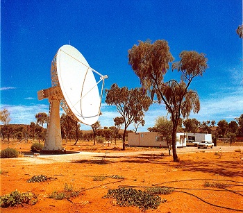
By 1976, the CSIRO team had established that satellite remote sensing was of substantial value to the Australian mineral exploration industry but data still had to come via tape from the USA because there was no facility in Australia capable of receiving the downlinked data from space. With support from the mineral industry, pressure was brought to bear on the government to refurbish an unused satellite tracking station in Alice Springs to establish the Australian Landsat Station in late 1978. CSIRO image processing concepts were used to define the specifications for the receiving station.
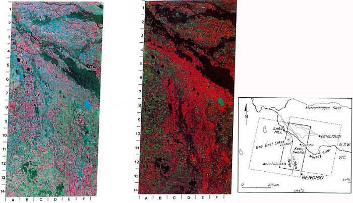
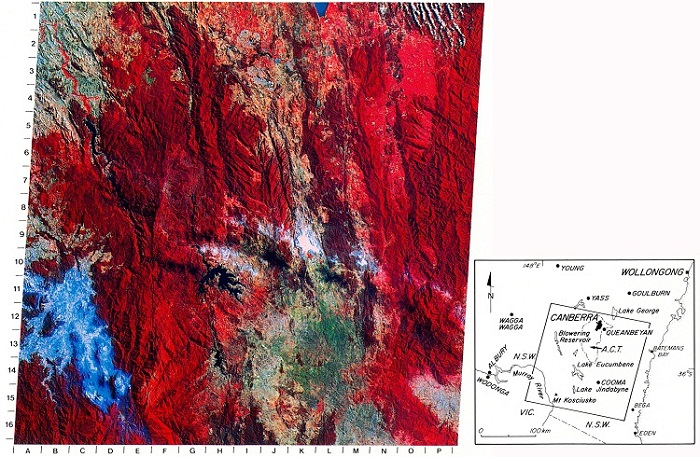
In 1982, a number of digitally-enhanced images from a range of Australian landscape types and cities were collected together in the book Satellite Images of Australia, edited by Ken McCracken and Christine Astley-Boden.
In 1984 a further upgrade to the station was needed so that Australian users could have access to the next generation of Landsat Thematic Mapper (TM) data. Despite the previous Landsat data not being optimised for geology, the new TM data was particularly significant in allowing the sensing of hydroxyl bearing rocks and minerals, a direct response to user requirements and pressure from the geoscience community. With support from the Australian Minerals Industry Research Association Ltd (AMIRA) and help from colleagues in the CSIRO Division of Radiophysics, the CSIRO team developed a simple, low-cost upgrade. As a result Thematic Mapper data became an indispensable part of the exploration industry’s tool-kit and were extensively used in environmental management, agriculture and hydrology.
Collaboration with Industry
In 1977, the CSIRO group began its first collaborative project with the Australian Minerals Industry Research Association Ltd (AMIRA) to improve the value of Landsat imagery. Since then, the group’s research has been supported by an ongoing series of consortium-funded AMIRA and Minerals and Energy Research Institute of Western Australia (MERIWA) projects (a total of 14 in 2009), in which they have not only developed new image processing and interpretation techniques and demonstrated their application to exploration, but also actively transferred the new technology to exploration companies, many of whom had their own in-house Landsat and image processing teams.
The willingness of exploration companies to join together to sponsor pre-competitive research has contributed greatly to the success of CSIRO’s remote sensing research and Australia’s internationally-competitive leadership. Projects have the added benefit of increasing industry know-how and access to test sites and locally-relevant case studies. Close contact with sponsors also results in immediate implementation of new discoveries, much faster than relying only on peer reviewed publication.
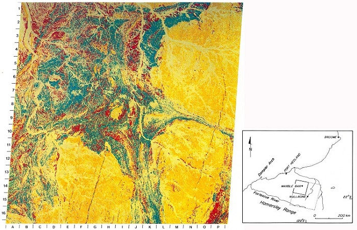
As Ken McCracken recalled regarding the impact of the Marble Bar image (above):
The Marble Bar image was the moment of truth for the mining industry. Up till then they were quite uninterested in satellite imagery ‘ Marble Bar turned them on big time. They could see geology they had only guessed at previously. Ten companies signed up for collaborative research with quite indecent haste. Seldom do you see ‘moments of truth’ ‘ that was one. Everything that happened in remote sensing in my division derived from that moment (and that image).
Mineral Mapping
By the early 1980s, when most of the major exploration companies were regularly using multispectral remote sensing as part of their operations, the group turned its attention to the development of the next generation of hyperspectral remote sensing instruments capable of mapping the minerals on the Earth’s surface in much more detail. This was the beginning of an increased focus that continues to the present day, on remote sensing systems designed specifically for the needs of the geosciences.
To meet the industry-driven goal of being able to map 20 minerals from the air within 10 years, they needed to develop field and aircraft systems to make measurements from the mid-infrared to the visible portion of the electromagnetic spectrum. Thus in 1982 came the first airborne survey demonstrating the identification of specific mineral species from 10 ,000 feet. The (subsequently commercialised) PIMA field spectrometer, the unique airborne CO2 laser spectrometer (MIRACO2LAS), the SWIPS and TIPS Fourier transform spectrometers and new software to calculate the relative abundances in mineral mixtures were just some of the further outcomes that allowed the team to meet their goal. They had clearly demonstrated that it was possible to identify ‘ in the field, from the air and eventually from space ‘ the surface alteration minerals that might be associated with buried ore deposits below.
This information helps companies select potential targets from Australia’s vast and often inhospitable terrain, thus reducing both the time and cost of exploration.
After the Australia Prize and into the Future
COSSA and AMET CRC
During the mid 1980s Ken McCracken, motivated to bring focus and order to Australia’s scattered space science and earth observation efforts, established the CSIRO Office of Space Science and Applications (COSSA), while Andy Green took his experience in signal analysis forward as Director of the Australian Mineral Exploration Technology Cooperative Research Centre (AMET CRC).
Continuing the Mineral Mapping initiatives Jon Huntington led CSIRO’s ongoing research into new hyperspectral remote sensing technologies specifically for mineral exploration. As he said at the time: the Australia Prize is just the beginning
ARIES
With the recognition of the power of remote sensing that the Australia Prize had attracted and driven by a desire to make the accumulated spectroscopic research knowledge routinely available, Jon Huntington set his sights again on space. With support from AMIRA and the space-company Auspace, plus interest from the Canada Centre for Remote Sensing and the British Geological Survey, he developed the ARIES (Australian Resource Information and Environment) satellite project.
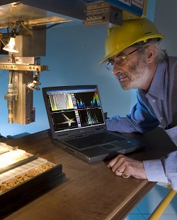
The HyLogging® concept using drill core samples
Though after some seven years of refinement and frustration it ultimately failed to gain adequate investment, and in lieu of any other nation (even by 2009) launching a geologically adequate hyperspectral satellite, Jon took all the accumulated experience gained from image processing of Landsat, PIMA, Geoscan, HyMap, AVIRIS, and led his team into remote sensing the mineralogy of the millions of metres of drill core stored in the nations public and private core libraries. Establishing the HyLogging® concept Jon Huntington believes the ability for geologists to implement remote sensing ‘up close and personal’ and at a fraction of the cost of airborne and satellite sensing will ultimately lead to a ‘next generation’ of satellite sensing for geology because the ‘value proposition’ will have been ultimately recognised and understood. At this time, too, the leadership provided by the special requirements of the geosciences will again be taken up in the interests of global environmental, agricultural and climate sensing.
Concluding remarks
Fundamentally the technologies of remote sensing should not, Jon thinks, be limited by discipline or scale of application. However they will inevitably continue to be beset by the challenges of balancing slowly developing national priorities for space investment with the shorter term needs and value propositions of the private sector. The important thing is to allow the next generation of scientists to realise their dreams while listening to their would-be users. He believes the take home messages behind the Australia Prize success are:
- Multidisciplinary people and approach. Harnessing the best ideas, often involving integration of pieces developed elsewhere for different purposes. Regular overseas visits to stay in touch and not re-invent wheels, and pursuing locally relevant adaption.
- Understanding user requirements (listening to the market).
- Involvement for the private sector (AMIRA), which provides financial support and facilitates technology transfer, commitment and immediate take-up of the discoveries.
- A simple and supportive management.
- Doggedness and focus (not trying to do too much) and allowing a skunk works approach where management has confidence in its people who leaves them sufficiently alone.
Sources
- Huntington J, Thompson J, 2010, Personal communication.
- McCracken KG, Astley-Boden CE, 1982, Satellite Images of Australia, Harcourt Brace Jovanovich Group (Australia), Pty Ltd, Sydney Melbourne (now Elsevier Australia).