Regolith geochemistry for mineral exploration
Four decades of basic and applied research carried out by groups in CSIRO and collaborating organisations have changed the way mining and exploration companies go about exploring for mineral deposits in Australian’s regolith dominated terrains as well as in comparable terrains around the world.
CSIRO commenced a strategic initiative in the early 1970s focused on understanding Australia’s landscape with the objective of overcoming major difficulties in mineral exploration caused by the long history of weathering and erosion. In such landscapes, outcrops of fresh (unweathered) rock are rare. Instead, a cover of weathered rock, iron-, silica- or calcium- rich surface crusts, thick soils and, in many places, younger sediments, collectively referred to as the regolith, conceal bedrock and any mineral deposits it may contain.
The success of this initiative was the result of geological, geochemical and geophysical studies being carried out over a strategic time scale. It is also an example where CSIRO research, initially at Floreat in Perth and North Ryde in Sydney, broadened through collaboration with various federal and state organisations, universities, industry bodies, particularly the Australian Mineral Industries Research Association Limited (AMIRA), and numerous mining and exploration companies.
In Australia, exploration and mining companies have acknowledged that the research concepts, methods and technologies have greatly assisted in the discovery of some substantial gold deposits, including Bronzewing, Nimary, Jundee, Carosue Dam and Ghost Crab in Western Australia and Challenger in South Australia, and aided exploration in numerous other locations for a variety of commodities. The WA gold deposits have an endowment (reserves, resources and production to date) of some 13 million ounces of gold while the SA deposit has an endowment of 1.3 million ounces of gold.
The broadened research through the CRC for Landscape Evolution and Mineral Exploration and its successor the CRC for Landscape Environments and Mineral Exploration has greatly expanded the impact on mineral exploration. Furthermore, it has had a substantial impact on understanding and tackling environmental issues such as dry-land salinity and acid sulphate soils.
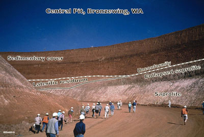
open cut Central Pit of the Bronzewing Gold Mine, Western Australia. [Photo: CSIRO]
A new research program is initiated
CSIRO mineralogist Arthur Gaskin, in his overview paper on geochemistry in 1950, suggested that Australia should develop geochemistry in as active and rigidly scientific manner as possible
In the late 1960s, Arthur Gaskin, by then Chief of CSIRO’s Division of Applied Mineralogy, commenced a strategic plan to tackle Australia’s deeply weathered terrains. A new research group would be formed at Floreat, conveniently close to terrains exemplifying the issues, and would complement existing strengths at the laboratories at North Ryde. Wilf Ewers (Officer-in-Charge at the Division’s Floreat Laboratories) participated in this planning with Maurice Mulcahy and Eric Bettenay from the CSIRO Division of Soils, and Roy Woodall and Richard Mazzucchelli from Western Mining Corporation. CSIRO’s Western Australian Advisory Committee, chaired by Sir Laurence Brodie-Hall, gave strong support. A recruitment campaign was initiated to attract scientists with the broad range of skills perceived to be crucial to the strategy’s success.
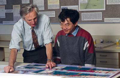
Initial key appointments were Charles Butt (in 1971), who had just completed a PhD in Applied Geochemistry at Imperial College, London (the leading university in exploration geochemistry), and Ray Smith (in 1973), a geologist-geochemist-geophysicist, with a background in academia in Canada and USA, and industry in Australia. Another was Ernie Nickel, an appropriately-named world-leading mineralogist recruited from Canada in 1971 to work on nickel gossans, the weathered outcrops formed from nickel sulphide ore deposits. His observations supported the laboratory research of electrochemist Mike Thornber, who was studying the oxidation of nickel sulphides to form these gossans. Alan Mann was recruited in 1973 to investigate dispersion of ore metals into groundwater. At North Ryde, Brian Gulson was appointed in 1973 adding skills in isotope geochemistry, complementing existing researchers including John Wilmshurst, Graham F Taylor and Keith Scott working on gossan geology, mineralogy and geochemistry.
Mineral exploration
Mineral exploration involves three broad stages: area selection, target definition, and ore deposit delineation. Area selection typically involves using broad geological concepts, regional geological mapping and syntheses, airborne geophysical surveys, and regional geochemistry (such as systematic sampling of sediments in drainage channels, or sampling weathering crusts). Favourable areas are selected based on interpretation of these inputs.
Target definition involves more detailed geological investigations of such favourable areas, further geophysics (which can include surveys carried out on the ground), closer spaced sampling of regolith materials for geochemistry, and initial drilling to provide subsurface sampling. The drill samples commonly come to the surface by air blast in the form of gritty powders and chips of subsurface regolith, important materials for geochemical analyses). Targets are located and ranked based on assessment of their characteristics.
Deposit delineation centres on investigation of the located targets, particularly using drilling, including diamond drilling (the most expensive form of drilling) where solid core samples of bedrock are produced. This stage also involves detailed geophysics (which may be done down drill holes) and geochemistry. Geological and geochemical investigations typically involve microscope studies of textures and minerals present, and can include sophisticated studies using isotope chemistry and investigating micron-scale fluid inclusion in transparent minerals such as quartz. Detailed feasibility studies for intended mining are then undertaken for the most promising deposits.
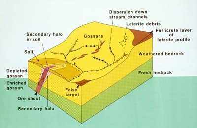
Geochemical haloes in laterite cover ‘ a breakthrough in mineral exploration
Areas of widespread cover by lateritic duricrusts and gravel were once considered a substantial impediment to mineral exploration. Building upon a previous study by Mazzucchelli and James (1966), Ray Smith’s research in 1979 at Gossan Hill/Golden Grove in the Murchison district, WA, revealed a kilometre-scale geochemical halo in lateritic regolith characterised by a broad suite of indicator elements. The halo was far greater in size than the ore deposit itself, a substantial advantage in exploration.
In 1980, Smith’s follow-up research achieved a further milestone by recognising a large (12 by 20 km), multi-element halo in regolith cover about the Greenbushes pegmatite deposit in WA. Collectively, results from the Greenbushes, Golden Grove and other sites showed haloes in a broad suite of indicator elements (Cu, As, Sb, Bi, In, Mo, Sn, W, Se, Ta, Nb, Li, B, Be, Au). Results demonstrated a break-through in exploration methods for a wide range of ore deposits, including base metal, rare metal, polymetallic and gold deposits.
Trials of laterite geochemistry for mineral exploration were then carried out with Greenbushes Tin Ltd, St Joe Minerals and Sons of Gwalia over the period 1980 to 1986 and included discovery of the Johnston Range gold deposits, 240 km north-west of Kalgoorlie. Although these deposits were modest in size, their discovery proved to industry at large the validity of the approach. Research increasingly involved multivariate statistical methods developed through collaboration with Norm Campbell of the Division of Mathematics and Statistics.
Landscape geochemistry and exploration models
In Australia
Charles Butt’s initial research was to investigate the geochemical signature of nickel mineralisation in the regolith. He commenced an ambitious project with Max Churchward (Division of Soils) to place the findings of studies at Mt Keith, some 400 km north of Kalgoorlie, in the context of the landforms and evolution of landscapes. Unfortunately, this project was curtailed by re-organisation of the Division of Soils, and it was another 15 years before directly comparable research recommenced, with projects coordinated through AMIRA. Nevertheless, results from this early study included the first geochemical dispersion study in Australia set in a landscape context (Butt and Sheppy, 1975), and the first regional regolith-landform map with mineral exploration, rather than agriculture, as its prime objective (Churchward, 1977).
During the 1970s, key aspects of landscape geochemistry in the Yilgarn Craton and its environs were established through numerous studies of regolith materials and the expression of different styles of mineralisation by Charles Butt, Ray Smith and their colleagues. This approach fitted well with similar research by Canadian geochemists, who had developed landscape-based Conceptual Models for describing geochemical dispersion and exploration techniques for selected regions of Canada (Bradshaw, 1975). Butt and Smith were confident that major advances in both understanding and in perceptions could be achieved by broadening the understanding developed in WA to span the Australian continent. Although existing knowledge was fragmentary and mainly unpublished, they collaborated with some 50 industry and research colleagues to assemble an Australian edition in the Conceptual Models series. This was published by the Journal of Geochemical Exploration (Butt and Smith 1980). The models are, in essence, valid today. They have been refined and incorporated in subsequent publications.
Elsewhere
There were echoes of the landscape geochemistry approach in studies by French researchers in West Africa, particularly by Hubert Zeegers and colleagues at the Bureau de Recherches Géologiques et Minières. Accordingly, after being asked by Professor Gerry Govett to assemble a volume in the series Handbook of Exploration Geochemistry, Charles Butt approached Hubert Zeegers to be co-editor/co-author. This collaboration resulted in developing a series of conceptual geochemical dispersion and exploration models for deeply weathered terrains in the tropics and sub-tropics, which formed the basis for the Handbook published in 1992 (Butt and Zeegers, 1992) and remains in use to this day.
Subsequently, research extended to study mineral deposits formed in the regolith, such as iron ore, bauxite, supergene gold, nickel laterite and calcrete uranium. All of these were shown to be products of the development and evolution of the regolith and landscape, over long periods of time and changing environmental conditions (Freyssinet et al., 2005 ; Mann and Deutscher, 1978).
Gold, gold, gold for Australia
Resurgence in gold exploration during the mid-1980s focused in WA on small but rich, easily mined deposits in the regolith. Gold is concentrated both at depth and in the near-surface lateritic horizons, but paradoxically was absent from intervening horizons, implying that gold is dissolved and reprecipated during weathering. Alan Mann and PhD student Jenny Webster concentrated on hydrogeochemistry of this problem. In 1986, Charles Butt, with PhD student Louisa Lawrance and others, investigated gold distributions in the regolith. Philippe Freyssinet, a student with Hubert Zeegers in Mali, collaborated on comparative studies in WA. These studies resulted in new understandings of gold mobility.
Regolith research at Floreat and North Ryde opened to wider industry sponsorship through AMIRA in 1987. The Laterite Geochemistry Project, led by Ray Smith, ran for three years. It evolved into Complex Lateritic Environments for a further two years, led jointly with Ravi Anand, a soil scientist recruited from the University of WA in 1987. Likewise, Charles Butt led the Weathering Processes project for three years and its successor, Dispersion Processes for a further two years; these focussed principally on gold, with another three year project, run concurrently, studying the platinum group elements. Others joining the teams included Melvyn Lintern, David Gray, Ian Robertson and Eric Grunsky, providing additional expertise in chemistry, soil science, geochemistry, geology and multivariate statistics.
A healthy degree of competition characterised this exciting period. Major advances were made in geochemical exploration, regolith mapping, regolith terminology and regolith-landform evolution, greatly assisting industry in making numerous new gold discoveries, including the Bronzewing, Nimary and Jundee gold deposits in WA (AMF, 1995). Considerable focus was on processes of geochemical dispersion and the development of exploration methods appropriate to the terrain. One unexpected finding was that gold is preferentially concentrated in soil carbonates (calcrete), making these materials important exploration sample media. This had considerable impact in the southern Yilgarn of WA with discoveries including the Aphrodite, Golden Cities, East Kundana, Ghost Crab and Carosue Dam gold deposits (AMF, 1999), and assisted in opening up the Gawler Craton in SA which had hitherto proved almost intractable to exploration, leading to a number of new gold deposit discoveries (AMF, 1997), the most notable being the Challenger Gold Deposit.
A step change came with the merging of the groups for the Yilgarn Transported Overburden Project (1993-1997), with Charles Butt taking on the leadership in 1995, freeing Ray Smith for his role as CEO of CRC LEME (below). With encouragement from AMIRA, a regolith geochemistry project in Queensland was developed, running over the period 1994-1997, led by Ravi Anand, with input from Queensland Department of Mines and the Australian Geological Survey Organisation (AGSO), now Geoscience Australia. The final project in this series, on Supergene Gold Mobilization (1997-2001) was led by David Gray.
The Cooperative Research Centre years 1995-2008
Mineral exploration research across Australia
A substantial expansion of regolith activities resulted from the award of the Commonwealth Government grant to form the CRC for Landscape Evolution and Mineral Exploration, to commence in July 1995. The proposal arose from the strong belief that enhanced collaboration across the country in regolith research would have a profound impact on understanding regolith and landscape evolution, particularly applied to mineral exploration.
The core parties were the Australian National University, University of Canberra, AGSO and CSIRO Exploration & Mining. Ray Smith was appointed CEO of the CRC, with Charles Butt as deputy and a Program leader.
Activities thrived through these core parties and a growing network of State geological organisations, universities and exploration/mining companies. Clearly, the Commonwealth CRC monies provided both the ‘glue’ to bind the parties together, as well as the catalyst that enabled expanded activities across the country to become ‘greater than the sum of the parts’. Important were projects that would not otherwise be possible, such as geological dating of regolith from locations across the country. The transfer of Melvyn Lintern to Adelaide developed collaboration with Primary Industries and Resources South Australia (PIRSA) and CSIRO Land and Water, principally to advance the application of calcrete geochemistry in the Gawler Craton.
Dry-land salinity
As the CRC moved into its mature years, dry-land salinity was emerging as a national problem of major significance. It was evident that the growth in regolith knowledge, coupled with recent developments in airborne electrical geophysical survey techniques had important implications in mapping, understanding and managing salt-affected lands. Broadening the CRC’s strategies into the environmental arena became part of the successful bid which resulted in the CRC for Landscape Environments and Mineral Exploration starting in 2001. Greater collaboration at all levels led to increasing the core parties to include two additional universities (Curtin University of Technology and the University of Adelaide), two state geological surveys (through PIRSA and the NSW Department of Mineral Resources), the Minerals Council of Australia and the formal involvement of CSIRO Land and Water. The expanded focus particularly included mapping dry-land salinity and the extent of inland acid sulphate soils in New South Wales, South Australia and Western Australia. Increased emphasis was also placed on geoscience teaching and education.
Legacy
The harvest years of the CRCs have been bountiful. Legacy arrangements for the published material, particularly in the form of Open File Reports freely available on the internet, will ensure the benefits, spanning widely across regolith science, will continue well into the future. Equally importantly, new groupings of researchers across Australia have emerged to tackle expanded regolith frontiers.
Source
- Butt CRM, Smith RE, 2009, Personal communication.